Two days before our hike, we made the decision to take the Ammonoosuc Ravine Trail, which begins near the Cog Railway on the mountain's western flank (Crawford Notch side, not the Pinkham Notch/Tuckerman's Ravine side). This trail ends at the AMC Lakes of the Clouds hut, nestled snugly in between Mt. Monroe and Mt. Washington, connected via the Crawford Path. It would be about 10 miles round-trip, but with the most elevation gain I've endured yet: ~4,500 ft. of elevation gain.
We awoke super early on Saturday, checked the Observatory forecast: clear and 50, with the wind chill in the 30s. Winter hat and mittens, check. Thermal long underwear, check. Fleece and raingear, check. PLENTY of water and food, check.

 We had an auspicious beginning to the day, when we were on Rte. 302 near Bretton Woods...a big bull moose by the side of the road!
 We parked near the railway and began. The trail starts out nicely enough, lulling you into believing that it won't be so bad. Dogs were happy to be in the woods running around, and so were we.


The river flows through the woods, with piles downed trees the evidence of winter's harshness on the flora. Were they pushed there from a river swollen with snowmelt? An avalanche? Perhaps a vicious ice storm followed by heavy snow, or one of the few major wind storms we've had earlier this year.

We were sharing the trail with a number of groups and individuals, and once the trail turned into a neverending stairmaster of granite rocks, the people lined up like ants to ascend.


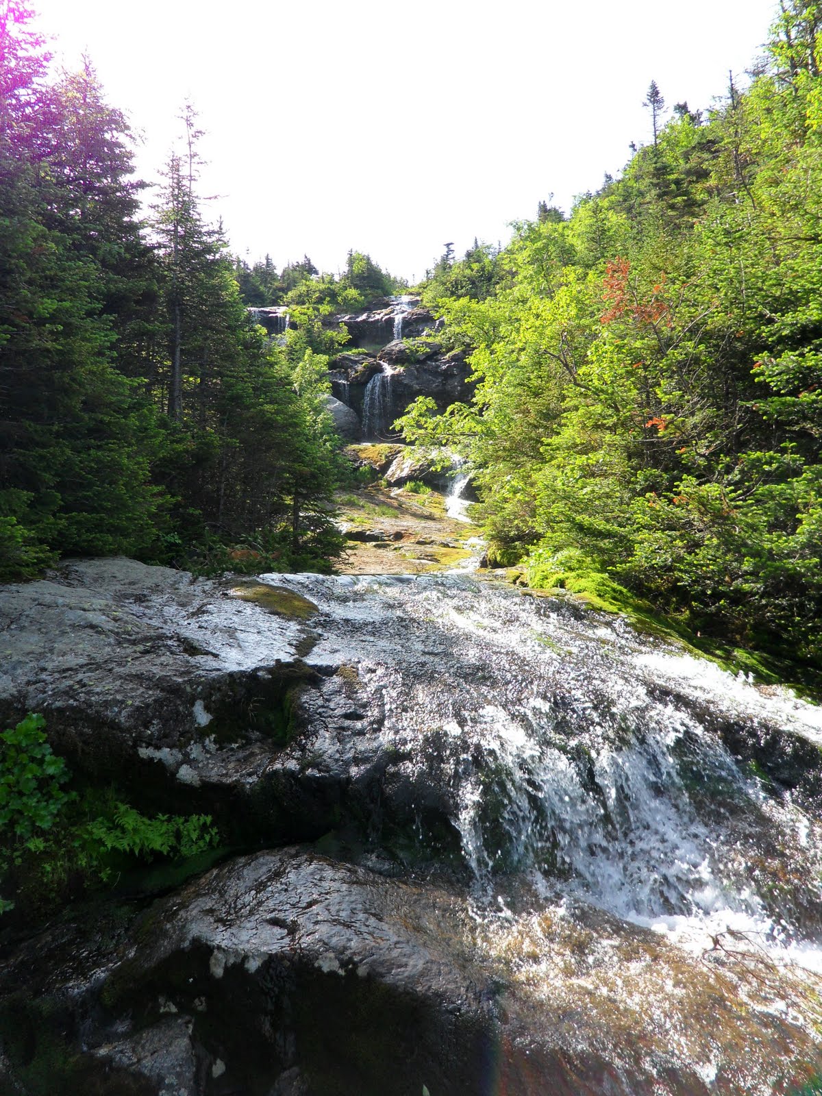
 Up, up, up, and up...the canopy opened up for views of the waterfalls we were about to climb up (slick vertical granite with very few hand- and footholds, yikes!) and also of the Cog Railway making its first trip up the mountain. We were doing it the old-fashioned way. Zoe and Shelby looked like mountain goats bounding up tall sections of rockface with little place for their paws.


We met a few cool folks on the trail, including a couple of native Pennsylvanians and Peter from NYC. We took a break at the AMC hut to take in the stunning views. The dogs were doing really well, thanks to the physical conditioning we've been doing and the coolness of the mountain air. Mt. Monroe on one side of the hut.


Only a couple more miles to go up to hit Washington...it looked like it was sooo close, just within reach, our goal for the summer. But it's a HUGE mountain, and looks are deceiving. We picked our way among boulders and millions of loose rocks, continuing our ascent to the peak. My legs were running out of energy, as I had blasted through my breakfast calories miles before. I was in need of my PB&Js at the top to regain some strength.


Another breathtaking view of the "northern Smokies," as I call them. The presidential peaks that go on and on, the White Mountains a lovely smear of jagged and rounded blues as far as the eye could see. No sign of clouds, we were lucky. It began to get colder and we put on more layers. One last break along the way and finally! We had summitted the highest peak in the Northeast!! 6,288 ft. Boy, it was chilly up there...


The unfortunate part is that the hike down was by far the toughest part of the climb.


 Spending 10% or more going down a mountain on your butt because it's essentially a granite rock face for a waterfall nearby is not the most pleasant experience. (Hey, I'm klutzy, okay?) My knees felt like knives were slicing through the patellas with every step, my muscles too tired to bear the brunt of the impact, and my legs began locking into place rather than flexing. It was a very slow, painful, and frustrating descent for me. I bit back tears for most of the way until two elderly, very overweight men passed us. How could they be doing so well on this trail, when someone who is much younger and fitter was in so much pain? The tears began in earnest, despite knowing we were in the home stretch.
 FINALLY! We got to the car, now super hot in the sun. Air conditioning at full-blast, hiking boots and sweaty clothes off, time for the long ride back and looking forward to sleeping like a rock after our hard word.